

Elevation Survey for Alluvial Fan Building Pad Site Design
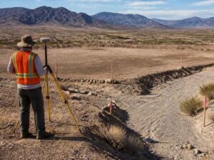
An alluvial fan can fool you. From the road, the ground looks flat and easy to build on. But that flat look hides slopes, old channels, and paths where water wants to run. Place a building pad in the wrong spot, and you invite flooding, settling, and costly grading fixes. An elevation survey shows what the eye misses. This guide explains how that data helps you set a pad in the right place on fan ground, and what to confirm before the dirt starts moving.
Why an Alluvial Fan Can Make a Building Pad Harder to Place
An alluvial fan is a wide, gentle spread of dirt and rock. It forms where a wash leaves the hills and slows down. Over time, water drops sediment and fans it out in a shape like an open hand. The result looks calm, but it’s still active ground.
Water on a fan doesn’t stay in one channel. It shifts and splits, then finds a new path in the next big storm. That means the low spot today may not be the low spot next year. A pad placed without this in mind can end up in the way of moving water.
The slopes here are also very slight. A drop of a foot over a long distance is hard to see by eye. Yet that small tilt still steers where water goes. An elevation survey measures those slight changes so the pad works with the land, not against it.
This is why a fan needs more study than a simple lot. The risk isn’t always what you see today. It’s what the water does in the storm you haven’t seen yet. Good elevation data lets you plan for that instead of hoping for the best.
Finding Subtle Elevation Changes Across an Apparently Flat Site
The main job on a fan is catching the changes you can’t see. A site can look level and still fall gently across its whole width. Those small drops decide where water pools and where it drains. Miss them, and the pad may sit lower than the ground around it.
An elevation survey maps the height of the land at many points. The surveyor records spot heights across the site and ties them to a fixed reference. From that data comes a contour map, which draws lines that connect equal heights. This topographic survey data helps show the high ground, low areas, and subtle slopes that affect building pad placement.
This map turns a plain-looking lot into a clear picture. You can see the high ground, the low ground, and the gentle valleys between. That’s the base for smart pad placement. Without it, you’re guessing at slopes too small to trust your eyes on.
The detail also helps everyone who works on the site later. The engineer designs from it. The grading crew builds it. One clear survey keeps the whole team measuring from the same ground.
How Sediment Patterns Can Influence the Building Pad Footprint
Fans are built from loose material dropped by past floods. That material isn’t the same everywhere. Some areas hold coarse rock and gravel near old channels. Other areas hold finer sand and silt where water slows and spreads.
These patterns matter for a pad. Loose or uneven fill can settle in different amounts under a building. A pad that sits across mixed ground may sink more on one side than the other. That kind of uneven settling can crack slabs and stress walls.
Elevation data helps you read these clues. Old channels often show as slight dips or ridges in the contour lines. By spotting them, you can shift the pad footprint onto steadier ground. You can also plan where extra soil testing or compaction may be needed before you build.
Pairing the survey with a soil report gives the fullest view. The elevation map shows the shape of the land. The soil work shows what sits under it. Together they help you place a footprint that stays level for the long run.
Using Elevation Data to Separate the Pad From Natural Flow Paths
The goal on a fan is simple. Keep the building above and away from the paths where water runs. An elevation survey is what makes that possible. It shows the flow paths that a flat glance would hide.
Contour lines point out the low routes water follows downhill. Those routes are the natural channels of the fan. A pad should sit on higher, firmer ground, clear of them. Here is what the data helps you plan.
- A pad set above the nearby flow paths, not level with them or below.
- A slope that carries runoff around the pad and away from the building.
- Room to keep the main channels open so water still has a place to go.
- A grading plan that guides water without pushing it onto a neighbor.
Working with the flow beats fighting it. When the pad sits high and water has a clear path, you cut the risk of flooding and erosion. Flood and drainage rules can vary by county, municipality, and project type, so confirm them early. An elevation survey gives the engineer the numbers to design that plan.
What an Elevation Survey Can Confirm Before Final Site Grading
Grading is the last step where mistakes get expensive. Once dirt moves, fixing a bad plan costs real time and money. So the survey does its most useful work before the machines arrive. It confirms that the design fits the ground.
An elevation survey can check several things at this stage. It confirms the pad height sits above the flow paths. It confirms the slopes carry water the right way. It also gives the cut and fill amounts, which are how much dirt to remove or add to reach the planned grade.
Knowing to cut and fill early helps the budget too. Balanced dirt on site can lower hauling costs. Extra fill trucked in can raise them fast. The survey turns those choices into real numbers before you commit.
This is also the time to line up your paperwork. Timing matters, since permits, inspections, and grading dates can all depend on the survey. Confirm your survey needs early so a delay doesn’t stall the whole project. A clear elevation survey keeps the grading crew working from solid ground.